1. The meeting of the Atlantic Ocean and the Caribbean Sea in Eleuthera Island, Bahamas

Eleuthera is one of several islands located in the Bahamas, approximately 80 km east of the capital, Nassau. The length of the island is about 180 km width is only about 1.6 km (1 mile) at its widest point. Light blue water of the Caribbean Sea shallow at one side of the island stands out in contrast with the blue of the Atlantic Ocean that it thousands of feet. One of the best places to see the contrast between the color of this extraordinary ocean is in Bridge Glass Window Bridge.
This bridge is one of the few places on earth where you can compare the blue of the Atlantic Ocean on one side of the road and green turquoise waters of the Caribbean Sea on the other, separated by a strip of stone that only 10 m wide. Above the natural stone bridges, concrete bridges have been built connecting the dots north and south Eleuthera by a paved road. Glass Window Bridge is one of the most visited places on the island.
For centuries, there is a natural stone bridge as a link between the north and south Eleuthera. Then in the 1940s, several storms that come in succession, destroying the natural bridge and concrete bridge was built as a replacement. For decades, the bridge is still functional with periodic repair, but a storm in 1992 and 1999 caused significant damage to the bridge. After Hurricane Floyd in 1999, practically nothing is original anymore of this window Glasgow bridge. Although the bridge was repaired and the Queen Highway re-connected within a few months, geography Eleuthera changed forever. Even after a decade, the workers keep busy strengthening the shoreline to re-open the road asphalt highly eroded.
2. Meets The Baltic Sea and the North Sea, Denmark / Sweden

In the resort town of Skagen you can watch an amazing natural phenomenon. This city is the northernmost point of Denmark, where the Baltic Sea and North Sea meet. Two pairs of opposite at this place can not join because they have a different density and salinity. The area where the sea meets the Baltic and the North Sea is shallow enough so that the contact surface is relatively small. Of course there is some mixing but very minimal.
This is also helped by the fact that the Baltic is not a post that makes the most of the water is in the basin of the Baltic and the water is constantly reduced salinity by rivers flowing into the Baltic. If not for a small hole into the North Sea, the Baltic will become the giant freshwater lake. Contact area is a nice sight to behold.
3. Horizontal Falls, Australia

Horizontal or Horizontal Waterfalls (nicknamed "Horries") is the name given to a natural phenomenon on the beach in the Kimberley region of Western Australia.
Despite its name, is a waterfall Horizontal, however this is a fast-moving tidal flow through a narrow slit, which connects the two canyons of McLarty Range, located in Talbot Bay. Reversed flow direction with every change of tide. When the tide in Kimberley reaches 10 meters, then the resulting significant difference in sea level on both sides of each canyon.
Canyons north (near the sea) in width is 20 meters and the southern canyon (more inland) width of 12 meters. This part of the canyon is also partly fed by fresh water from Poulton Creek.
4. Channels In The Great Barrier Reef, Australia

The Great Barrier Reef is the largest coral reef system in the world, consisting of nearly 3,000 individual reefs and 920 islands stretching along more than 2,650 kilometers over an area of approximately 345,000 square kilometers. Coral Reef is located in the Coral Sea, off the coast of Queensland, Australia.
The Great Barrier Reef is the world's largest single structure made by living organisms and can be seen from outer space. Reef structure is composed of and built by billions of tiny organisms, known as coral polyps. It supports tremendous biodiversity and declared a World Heritage Site in 1981. It is one of the seven natural wonders of the world.
Canals or channels that are visible in the image above, separated from Hardy Reef Hook Reef, a small reef which is owned by the Great Barrier Reef. This channel is often photographed from the air and an important location for scuba divers.
5. "Waterfall Underwater", Mauritius

Mauritius is an island nation officially called the Republic of Mauritius, or in French, République de Maurice, which is located in the Indian Ocean about 2,000 miles off the southeast coast of the African continent. An illusion of interest can be found in the western tip of the island. When viewed from the air, a sand and silt runoff create the illusion of an underwater waterfall. This deceptive visual impression will actually look when viewed from above. In fact, this illusion can be viewed in Google Earth.
6. The Great Blue Hole, Belize

Great Blue Hole is a large underwater sinkhole off the coast of Belize. It is located near the center of Lighthouse Reef, a small atoll 70 miles from the mainland and Belize City. Hole is circular in shape, with a diameter of 300m across and 124m depth. Great Blue Hole is part of the Belize Barrier Reef Reserve System, a UNESCO World Heritage Site.
It is a popular place among recreational divers, who are lured by the chance to dive in the crystal clear water and filled with several species of fish, including giant grouper, nurse sharks and several types of reef shark Caribbean reef shark and shark Blacktip.
7. Ball's Pyramid, Australia
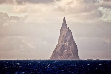
Ball's Pyramid is the rest of the erosion shield volcano and caldera. Ball's Pyramid is located at 20 kilometers (12 miles) southeast of Lord Howe Island in the Pacific Ocean. Ball's Pyramid height 562 meters, while the length of 1,100 meters and a width of only 300 meters, thus making it the world's tallest volcanic debris. Ball's Pyramid is part of the Lord Howe Island Marine Park in Australia.
This pyramid is named after its inventor, Lieutenant Henry Lidgbird Ball who discovered in 1788 at the same time he found the Lord Howe Island. The first person who came here believed was Henry Wilkinson in 1882, who is a geologist, Department of Mines of New South Wales. Climb Ball's Pyramid banned in 1982 by amendments to the Act Howe Island, and in 1986 all access to the island was banned by the government Howe Island. In 1990 the policy change and allow some climbing under strict requirements.
In 2001, a team of entomologists and conservationists landed on Balls Pyramid to map the flora and fauna. They were surprised, because there they found a stick insect (Dryococelus australis) which has been declared extinct.
8. Malé, Maldives

Malé is the capital and most populous city in the Republic of Maldives. Geographically located at the southern edge of North Malé Atoll (North Male Atoll). Malé Island is very densely populated, and building-banguna across his land.
Nearly a third of the population lives in the capital city of Maldives, and the population has increased from 20,000 in 1987 to 100,000 in 2006. Many, perhaps even most, are foreign workers in Maldives.
The Island of Malé is the fifth most populous island in the world, and is the island to 168 of the most populous in the world. Because there is no surrounding countryside, the entire infrastructure must be in the city itself. Water supplied from ground water desalinization.
9. Atlantic Ocean Road, Norway

Atlantic Ocean Road or the Atlantic Road is the road along 8.3 kilometers (5.2 mi) from County Road 64 that crosses through an archipelago in Eide and Averoy in More og Romsdal, Norway. This road passes Hustadvika, protected part of the Norwegian Sea, which connects the island with the mainland and the peninsula Romsdalshalvøya Averoy. This road also connects the village Karvag in Averoy and Vevang in Eida.
This road was built on several small islands and skerries, which are connected by several docks, viaducts and eight bridges - the most prominent is Storseisundet bridge.
This road is preserved as a cultural heritage site and is classified as a National Tourist Route. It is a popular site for automotive advertising films, has been declared as the best ride in the world, and has been awarded the title as "Norwegian Construction of the Century".
10. Rock Islands, Palau

Rock Islands, Palau is a small collection of limestone or coral uprises, ancient relics of hard coral reef emerged form the Palau Islands Southern Lagoon, between Koror and Peleliu, and is now part of the territory of Koror. There are between 250 and 300 islands in the group according to different sources, with total area of 47 square kilometers and a height of up to 207 meters. They are a World Heritage Site since 2012.
The islands are largely uninhabited and is famous for its beaches, blue lagoons and odd shape like an umbrella of many islands themselves. Rock Islands and the surrounding reefs makes Palau's popular tourist sites such as Blue Corner, Blue hole, German Channel, Ngermeaus Island and the famous Jellyfish Lake. One of the many lakes in the Rock Islands sea that provides home and security for some kinds of stingless jellyfish found only in Palau.
It is the most popular diving destinations in Palau, and offering the best and most diverse of the dive sites on the planet. Many of the islands' displays such as mushroom shape with a smaller base than what was on it. Curvature derived from erosion and dense community of sponges, bivalves, Kiton, snails, sea urchins and others who play mostly on algae.


0 comments:
Post a Comment